[ad_1]
Mesmerising branches and spirals of ice — reminiscent of abstract artwork — are often one of the perks of an ice-cold morning.
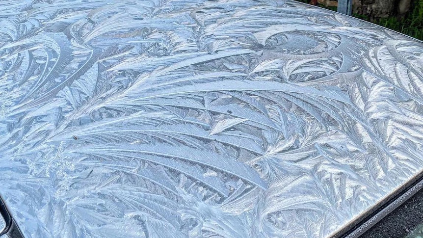
With temperatures plunging across the country, many have taken to social media to share photos of the breathtaking natural displays, including Matt Worrall in Western Australia who discovered an ice pattern resembling etched silver on his car roof in Donnybrook.
“I’ve never seen anything like it,” he said. “It was amazing.”
“It was parked under the jacaranda tree and I was just wondering if it was done by the wind or the leaves of the jacaranda. I couldn’t work it out.”
So what’s behind the works of art, courtesy of Mother Nature?
Imperfections creating art
In its simplest form, the intricate patterns are the result of tiny imperfections on a surface, such as scratches, specks of dust, salt, or even residue from washer fluid, according to Bureau of Meteorology forecaster Jessica Lingard.
These imperfections disrupt the even pattern of the ice crystals, causing them to branch out in a variety of different directions.
Ms Lingard said different environmental conditions also had a role to play in how the ice crystals formed, and whether they looked like plates, columns, or dendrites.
“Small changes in humidity, temperature or wind speed or direction will change how the frost, ice, looks as it freezes,” she said.
She said the clarity of the pattern, and whether it appeared clear and glass-like, or more dull in appearance, depended upon whether it was frost or ice.
“Frost occurs when water condenses out of the air directly onto a surface,” Ms Lingard said.
“Ice crystals form when liquid water freezes.”
In the case of the striking, glassy display on Mr Worrall’s car roof, Ms Lingard said it was ice.
“So [to achieve this] the temperature of the air would have dropped slowly overnight, allowing moisture to condense out of air first, which subsequently froze,” she said.
She said it was likely to have frozen quickly, causing the feather-like patterns to “knit” together.
More icy mornings ahead
With a large part of Australia currently experiencing a mid-winter rain hiatus of clear skies and light winds, the chance of seeing the unique patterns over the next two days is high.
Parts of southern Queensland, including Warwick and Applethorpe, on Tuesday experienced their coldest July morning since 2019 when temperatures dropped to -5 degrees Celsius.
Parts of inland New South Wales, such as Glen Inness, fell to -6.8C.
The icy pool of air moved over the country in the wake of a cold front.
While temperatures are not expected to fall quite as far, BOM was forecasting widespread frost and sub-zero temperatures to continue on Wednesday morning across parts of eastern Australia, extending from the interior of south-east Qld, through eastern NSW and into north-east Victoria, as well as WA’s Goldfields and Wheatbelt regions.
The frost is forecast to clear from WA on Thursday, remaining through the same regions of NSW, Vic, and Qld and becoming confined to NSW by Friday.
[ad_2]
